SWITZERLAND
|
|
ALL ABOUT SWITZERLAND |
|
CANTONS | ||||
|
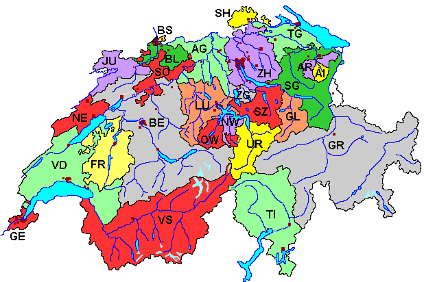
Political Map Statistics Abbreviations Coat of Arms |
Switzerland's 26 Cantons (Federal States)Switzerland's 26 cantons are the federal states of the Swiss confederation. For historical and geographical reasons they differ widely: The largest canton (Graubünden/Grisons) has 192 times the area of the smallest (Basel-Stadt) but even less inhabitants while canton Zurich has about 80 times more inhabitants than canton Appenzell Innerrhoden. Political Map of Switzerland's Cantons
|
 |
Number plates on Swiss cars show both the coat of arms of the Swiss confederation and of the canton as well as the abbreviation of the canton in between. The following table shows the cantons with their abbreviations and basic statistical data. The abbreviations are often used in Switzerland, also as domain names for all official websites of cantonal administrations (see links in fourth column). |
| Coat of Arms | Entry into Con- fed. |
Name of Canton | Abbr | Area km² sq mi |
Inhabitants | Popu- lation Density /km² /sq mi |
Lan- guage |
Capital | Inhabi- tants |
|---|---|---|---|---|---|---|---|---|---|
| <1415> 1803 |
Aargau | AG | 1,404 542 |
556,000 | 396 1026 | d | Aarau | 15,000 | |
| 1411 1513 [1597] |
Appenzell Ausserrhoden | AR | 243 94 |
53,000 | 218 564 | d | Herisau | 15,000 | |
| 1411 1513 [1597] |
Appenzell Innerrhoden | AI | 173 67 |
15,000 | 87 224 | d | Appenzell | 5,000 | |
| 1400 1501 [1833] |
Basel-Land | BL | 518 200 |
263,000 | 508 1315 | d | Liestal | 12,000 | |
| 1400 1501 [1833] |
Basel-Stadt | BS | 37 14 |
186,000 | 5027 13286 | d | Basel city guide |
165,000 | |
| 1323 1353 |
Bern | BE | 5,959 2301 |
950,000 | 159 413 | d,f | Bern city guide |
122,000 | |
| 1481 | Fribourg Freiburg | FR | 1,671 645 |
243,000 | 145 377 | f,d | Fribourg Freiburg |
33,000 | |
| 1815 | Genève [Geneva] | GE | 282 109 |
419,000 | 1486 3848 | f | Genève [Geneva] city guide |
178,000 | |
| 1352 | Glarus | GL | 685 264 |
38,000 | 55 144 | d | Glarus | 6,000 | |
| 1498 1803 |
Graubünden Grischuns Grigioni |
GR | 7,105 2743 |
186,000 | 26 68 | d,r,i | Chur | 32,000 | |
| [1979] | Jura | JU | 839 324 |
69,000 | 82 213 | f | Delémont | 11,000 | |
| 1332 | Luzern [Lucerne] | LU | 1,494 576 |
352,000 | 236 610 | d | Luzern city guide |
73,000 | |
| 1406 1815 |
Neuchâtel | NE | 803 310 |
167,000 | 208 539 | f | Neuchâtel | 32,000 | |
| 1291 | Nidwalden | NW | 276 107 |
39,000 | 141 366 | d | Stans | 7,000 | |
| 1291 | Obwalden | OW | 491 190 |
33,000 | 67 174 | d | Sarnen | 9,000 | |
| 1412 1803 |
St.Gallen | SG | 2,026 782 |
455,000 | 225 582 | d | St. Gallen | 70,000 | |
| 1501 | Schaffhausen | SH | 299 115 |
74,000 | 248 641 | d | Schaffhausen | 33,000 | |
| 1291 | Schwyz | SZ | 908 351 |
133,000 | 146 379 | d | Schwyz | 14,000 | |
| 1400 1481 |
Solothurn | SO | 791 305 |
247,000 | 312 809 | d | Solothurn | 15,000 | |
| <1460> 1803 |
Thurgau | TG | 991 383 |
230,000 | 232 601 | d | Frauenfeld | 22,000 | |
| <1403> 1803 |
Ticino | TI | 2,813 1086 |
315,000 | 112 290 | i | Bellinzona | 16,000 | |
| 1291 | Uri | UR | 1,077 416 |
35,000 | 33 84 | d | Altdorf | 8,000 | |
| <1536> 1803 |
Vaud | VD | 3,212 1240 |
632,000 | 197 509 | f | Lausanne city guide |
116,000 | |
| 1403 1815 |
Valais Wallis | VS | 5,225 2017 |
281,000 | 54 139 | f,d | Sion Sitten |
28,000 | |
| 1352 | Zug | ZG | 239 92 |
102,000 | 427 1105 | d | Zug | 23,000 | |
| 1351 | Zürich | ZH | 1,729 668 |
1,242,000 | 718 1860 | d | Zürich city guide |
342,000 | |
| |
1291 | Switzerland [total] | CH | 41,293 15,943 |
7,451,000 | 180 467 | d,f,i,r | Bern city guide |
122,000 |
Some Notes on Statistical Information
> See also: www.gov.ch Register of the internet sites of Switzerland's Administration and Public Services on federal, cantonal and communal level. Most of the websites listed there are only available in the (German, French, Italian, Rumantsch), however. |

Short quotations allowed but with precise declaration of origin (Link).
Reproduction of substantial parts and pictures in printed or electronic form
only with explicit written consent by the editor.
| Disclaimer | Privacy Policy | www.all-about-switzerland.info © 2005-2010 All Rights Reserved | Editor | ||